The International Transentient Cartographicacy Project
 "The only real voyage of discovery consists not in seeing new landscapes,
but in having new eyes, in seeing the universe with the eyes of another,
of hundreds of others, in seeing the hundreds of universes that each
of them sees."
"The only real voyage of discovery consists not in seeing new landscapes,
but in having new eyes, in seeing the universe with the eyes of another,
of hundreds of others, in seeing the hundreds of universes that each
of them sees."
— Marcel Proust
The International Transentient Cartographicacy Project aims to expose both the continuities and the distortions of contemporary urban experience through story-telling and superimposed, visual displays. The ITCP consists of an interactive, on-line map of Mexico City, Mexico as well as a roving, multi-media, projection-installation presented throughout the streets of Dublin, Ireland.
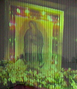
During the fall of 2003, we conducted interviews with family, friends and other close sources who had been to or lived in Mexico City to collect stories about their personal experiences of the city. These stories were presented in an on-line, interactive map, which we created by integrating a simple, spatially-oriented message board with a complex PHP and MySQL database-driven Open Source application called ActionApps (designed and developed as a special project for non-governmental organizations and funded by the Association for Progressive Communications). The online map continues to be openly available for the addition of new stories about Mexico City, as well as for anyone to consider and post comments on at will. In March 2004 we traveled to Mexico City for the second phase of the project. During a two-week period we explored and documented the city with video, film and photographs, using the map of collective memories as both a navigational and spiritual guide. In June 2004 we are scheduled to present the project as part of the Wandering Rocks, Revolving Doors collective (an international group of artists assembled under the direction of Susan Sakash of the New Ground Center for Collaborative Learning) in Dublin, Ireland during the ReJoyce Dublin 2004 Festival. Our individual project (the ITCP) will take the form of a series of video and slide projections combined with sound and will be projected in various, predetermined public locations as well as in intimate settings throughout the city of Dublin. The festival marks the one hundredth anniversary of Bloomsday (the day on which James Joyce's landmark novel Ulysses is set) and promises to be an extravagant, international event with symposiums, lectures, literary readings, film screenings, outdoor art and music performances and other activities. The ITCPs relationship to Ulysses is through the Wandering Rocks episode (or, the tenth chapter of the novel) which describes the residents of Dublin as they move about the city during the afternoon of June 16, 1904. The novel animates the interconnected and cyclical nature of history, depicting central characters as characters from the ancient Greek epic The Odyssey, as they go about a typical day in Dublin, while also referencing other various literary and philosophical sources. Similar to the spirit of Ulysses, the ITCP aims to animate the interconnectedness of culture by superimposing everyday phenomena from Mexican and Irish culture as experienced in the capital cities of both countries. Some of the things that our project will show in the multi-media displays in Dublin will include Mexico City residents as they enjoy afternoon boat rides through Xochimilco while floating down the Liffey River, altars to the Virgen de Guadalupe projected inside of St. Marys Abbey, a pasero bus ride through the streets of Coyoacan projected inside of a parked Dublin public bus, and vendors near the Aztec ruins of Templo Mayor projected inside of the Merchants Arch near Hapenny Bridge. The project, for us, is an aesthetic gesture of combining our own personal, cultural heritages as well as a forum to explore the endless relationships between literature, art and life.
Challenging the authority of traditional maps, which demarcate geographical boundaries based on pre-determined systems of coordinates or data, the International Transentient Cartographicacy Project maps out a conceptual space according to a compilation of non-categorical and subjective information—memories and experiences which have been solicited and gathered from friends, family and sources close to us. Like dream logic and imagery, it illustrates (and animates) a space that exists somewhere between the empirical world and some sort of nebulous, collective memory.
Our approach borrows influences and ideas from the critical cartography movement (led by the late British scholar J.B. Harley) which approached the study of maps as sociopolitical constructs that interpret and reflect historical power structures. Just as they did before us, we are challenging the modernist approach to map-making by highlighting the imbalance of power in terms of information gathering and distribution and in turn offering an alternative perspective.
Maps have traditionally aimed to be graphic representations of given territories based on the prevailing knowledge of the time in which they were created. Over the centuries, of course, these representations fluctuated as political power structures changed, new territories were conquered or discovered and new knowledge and theories were expounded upon. The trail of cartographic representations left in the wake of political turmoil shows exaggerations of one type or another due either to a change in knowledge or a change in motivation. Ironically, the first attempt to create a cohesive world map was interrupted by the First World War, as nations battled over territorial and political boundaries. As history has shown us, maps have become both the provocateurs and the documentation of so much political struggle. Even in the most neutral circumstances, the craft of map-making begs questions about what type of representational approach is more accurate. The on-going debate over the art/science dualism in cartographic representation over the years is prescient to the ever-evolving practice of informational design and advertisement. Those responsible for making the maps (the government, the geographical explorers and the map-makers) are the ones who are ultimately responsible for the distribution of information. And given such historical patterns one wonders how much is real, objective data and how much is creative influence.
In an attempt to rattle the foundations of cultural order (with influences from Foucault and post-structural theory) we are questioning the very basis of maps and the rationalization for insinuating boundaries of any type. With a subjective approach to space and time, we have become interpretive explorers through the continual and fluid processes of interaction, comparison and transgression. This project is one of perceptual, rather than definitive cartography.
Links